Models of Jerusalem

Models of Jerusalem

  •   Four Periods in the History of the City
  • Jerusalem today (Photo courtesy of the Jerusalem Center)
     

    The ancient stones of Jerusalem, the capital of Israel, are imbued with millennia of history. In 1000 BCE King David made the city, located in the heart of the country, his capital. Over the centuries, Jerusalem, held sacred by the three major monotheistic religions, has been a city of places of worship, community life and cultural development as well as a focus of conflict. Today, it is a growing metropolis which faces the challenges of modern urban life while preserving its unique historical and spiritual nature.

    The interested visitor can view, in Jerusalem, models depicting the city in four periods of its history:
     
    • in the First Temple Period (c. 960-586 BCE);
    • during King Herod's reign in the first century CE (Second Temple Period, 538 BCE - 70 CE);
    • in the latter part of the 19th century, under Ottoman rule;
    • present-day Jerusalem, planning for the future


  •  
  • JERUSALEM IN THE FIRST TEMPLE PERIOD

  •  
    Photo courtesy of Yad Yitzhak Ben-Zvi (Sarit Uziely)Some 3000 years ago, King David made Jerusalem his capital. Solomon, his son, expanded the city and built the Temple to God.
     
    The building of this, the First Temple, is reported to have been started in the fourth year of Solomon's reign, and to have taken seven years to complete. As the central place of worship in the country, it was in use for four centuries. Its fame among the nations of the region rested on the splendor of its outer appearance and its inner appointments, and on the holy ark of the covenant which it housed. The Temple was located near the royal palace and enjoyed royal patronage. In 586 BCE, it was destroyed by the Babylonians.
     
    What did Jerusalem look like in the First Temple period? A model of the ancient city, built under the auspices of Yad Yitzhak Ben-Zvi, is located in an unassuming house in the heart of the Old City's Jewish Quarter. Planned as an educational tool to teach the history of Jerusalem, the model is scaled at about 1:250 and covers a surface of 35 square meters. Miniature replicas of stone structures, as well as of the fortified wall, were constructed on the basis of archeological evidence. Archeologist Dan Bahat, an expert on Jerusalem, is the scientific adviser for the model.
     
    A sound and light show is screened several times daily in Hebrew, English, French and Russian; by using special glasses, the viewer embarks on a three-dimensional "tour" of the sites of biblical Jerusalem. Particular emphasis is placed here on the well-planned water systems carved out of rock during the rule of the Kings of Judah. In his trip into the past, the viewer learns about the conquest of Jerusalem by King David three millennia ago, the construction of the Temple, the cutting of the Siloam Tunnel (to safeguard the city's water supply) and the horrors of the Babylonian siege and conquest in the sixth century BCE.
     
    The First Temple has not been reconstructed: while detailed descriptions appear in biblical sources, no archeological evidence has been uncovered to date. In the model, therefore, the building is schematically represented by a box.
     
    However, the myth of the Temple's splendor and its treasures persists. At the beginning of the 20th century, Finnish theologian and poet Walter H. Juvelius conceived the idea of digging in the City of David, which is located on a ridge south of the present Old City, and is, in fact, the original site of Jerusalem. By reinterpreting certain biblical passages, Juvelius believed, the treasures of the First Temple could be found. As fate would have it, he met Captain Montague Parker, a young officer recently released from the British army, and managed to win him over to his plan. Parker took advantage of his social position and family connections to raise a sum of money with which to begin excavations in search of King Solomon's treasures. The investors were promised a large portion of the treasure when it was found. Parker led the expedition that arrived in Jerusalem in 1909 and began to dig in the City of David and in the Siloam Tunnel, which he believed led to the Temple Mount.
     
    Father Vincent, a prominent Jerusalem archeologist associated with the Ecole-Biblique, joined the excavations. While other members of the expedition pursued excavation of the canals, the Siloam Tunnel and the other ancient water systems, Vincent documented the findings.
     
    With the assistance of experts brought from Europe, Parker dug through a complex system of canals in his attempt to penetrate the Temple Mount. The work was done under harsh winter conditions, with the constant threat of landslides and the collapse of the canals - and was kept secret for two years (1909-1911).
     
    In the spring of 1911, when Captain Parker realized that the Ottoman authorities would not allow him to continue digging, he bribed some Wakf (Moslem religious) officials, and, together with some of his men, penetrated the Temple Mount and began excavating. He was quickly discovered, and the members of the expedition had to flee the country.
     
    Interest in the affair continued, however, and journalists wondered whether the treasures of the Temple had been discovered and hidden. However, the expedition had in fact not found any of the Temple's treasures.
     
    Exhibited together with the model are Father Vincent's sketches and maps of the water canals, as well as his photographs (on glass plates). There are also newspaper clippings in several languages about the stir caused by the excavation.
     
    An account of the excavation was published by Father Vincent in 1911 in his book "The Underground Jerusalem"; his findings are consulted to this day by researchers of the First Temple period.
     
     
  • JERUSALEM IN THE FIRST CENTURY CE

  •  
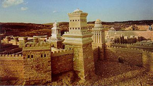
    Photo courtesy of the Holyland Hotel"Like a snowy mountain glittering in the sun" - that is how Josephus Flavius, a first century historian, described the outer appearance of the Second Temple, built of three different shades of marble. Today not much remains in the way of concrete evidence of the splendor of the Temple: just the Western Wall, remnant of the Temple Mount enclosure, as well as recent archeological discoveries, literary descriptions, depictions on coins and the fresco in the 3rd century synagogue at Dura Europos in Syria.
     
    The interested observer, however, can see a model (scale 1:50) of Jerusalem during the Second Temple period - originally built at the Holyland Hotel and later moved to the Israel Museum - in modern Jerusalem. Israelis and tourists, as well as groups of schoolchildren, come to view the model and to learn about the city before its destruction by the Romans in 70 CE.
     
    The model was built with the initiative and resources of Mr. Hans Kroch under the supervision of the eminent archeologist Professor Michael Avi-Yonah of the Hebrew University. Professor Avi-Yonah, in turn, based his work on information found in the writings of Josephus Flavius, in the New Testament, in Jewish sources such as the Mishna and the Talmud and in the traditions concerning important buildings of the time.
     
    Professor Avi-Yonah supervised the construction of the model and its renovation until his death in 1974. Mrs. Eva Avi-Yonah drew the plans of the entire model, as well as sections and facades of most of the buildings. As far as possible, the model has been constructed of the materials used at the time: marble, copper and iron, stone and wood.
     
    Dr. Yoram Tsafrir of the Hebrew University, who, since the death of Professor Avi-Yonah, has been in charge of updating the model in accordance with the latest archeological discoveries, explains that there may be some inaccuracies in the model, but they are minor. Thus, for example, the round Herodian theater is now known not to be in the right location. "But since we do not know where exactly it was situated, we leave it where it is," maintains Professor Tsafrir, whose expertise is in the Hellenistic, Roman and Byzantine eras. He explains that recent archeological findings also prompted a change in the approachway to the Temple. "Now we know that the entrance was to the south," the archeologist states.
     
    Probably the most imposing part of the model are the walls, some as much as 70 cm. high - 35 m. high in actuality. Ancient Jerusalem was defended by three such walls on its vulnerable northern side, while a single wall was sufficient on the west, south and east, because of the deep valleys surrounding the city on these sides.
     
    Equally imposing are the three towers built by King Herod (37-4 BCE) to protect his palace. The largest, 45 m. high, was called Phasael, after Herod's brother; the second, Hippicus, 40 m. high, was named after an otherwise unknown friend of the king; and the third, 27.5 m. high, was called Mariamne after Herod's queen, whom he loved but nevertheless condemned to death. This tower is more ornate than the other two towers, because, in the words of Josephus, "the king considered it appropriate that the tower, named after a woman, should surpass in decoration those called after men."
     
    Herod's palace, currently being redesigned in the model, consisted of two main buildings, each with its banquet halls, baths and bedrooms for hundreds of guests. All around the palace were groves of trees, ponds and walkways.
     
    The hill east of the palace, the Upper City, had been inhabited during biblical times, but was deserted after the Babylonian conquest of Jerusalem in 586 BCE. During Herod's reign and in the first century, the Upper City, once more inhabited, was the residential quarter of the Jerusalem aristocracy and priestly families. The Upper Agora, surrounded by porticoes, was the "forum," the place where citizens assembled for business. Another gathering place, this one on the Temple Mount, was the Royal Hall, built by Herod - one of the largest buildings in the Roman Empire.
    Clearly discernible in the model are luxurious private buildings, remains of which were uncovered recently, mostly in excavations in the Jewish Quarter. The buildings included large rooms decorated with frescoes and mosaics, bathrooms, water cisterns and ritual baths. One such building, revealed in 1970, is known as the "Burnt House." Filled with the implements of everyday life in the first century CE, it was completely burnt as a result of the conflagration that reduced the Upper City to ashes in the year 70 CE.
     
    The only permanent water source of the city in this period, the monumental Pool of Siloam, is clearly distinguishable in the model. It was fed by waters of the Gihon Spring diverted through Hezekiah's Tunnel, built in the 8th century BCE.
     
    Visible also are the Western Wall and the Second Temple, built by the returnees from Babylon under Zerubabel (sixth century BCE). Similar to the Temple of Solomon but less ornate, it was enlarged by King Herod and made into the magnificent edifice shown in the model. The important sections of the Temple included separate courts for men, women and priests, as well as the Holy of Holies. The Beautiful Gate led to the Women's Court, beyond which women were not permitted. The Gate of Nicanor (named after a rich Jew from Alexandria who donated the door), distinguished by its copper color, leads from the Women's Court to the innermost court; it is approached by fifteen curved steps upon which the Levites stood singing and playing music.
     
    "The model, which needs constant refurbishing and maintenance," says Professor Tsafrir, "serves to depict for the visitor how Jerusalem looked and functioned in the Second Temple period." One can, of course, study the model and then visit the actual excavations in the Old City of Jerusalem.


  • JERUSALEM IN THE NINETEENTH CENTURY

  •  
    Photo courtesy of the Tower of David Museum of the History of JerusalemThe visitor to Jerusalem often begins his tour of the Old City at the Jaffa Gate. The Tower of David Museum of the History of Jerusalem is located in the magnificent nearby Citadel. Modern methods, including photographs and copies of original artifacts, audio-visual exhibits, illustrations and more, conjure up before the visitor's eyes a colorful procession of events from Jerusalem's variegated history. Jerusalem is all there - from its ancient beginnings to the 20th century.

    And should the visitor, on entering the archeological garden, descend some sixty steep steps into an ancient cistern, he will find himself face to face with a portrait of Jerusalem as it was in the 19th century - in the form of a remarkable model, built by a Hungarian Catholic, Stephan Illes (pronounced il-yesh), a native of Bratislava, at the time part of the Austro-Hungarian Empire.

    The area of the model, built to a scale of 1:500, stretches from the Mount of Olives in the east to the Russian Compound (the construction of which began in 1858) in the west, and from the spring of Ein Rogel in the south to beyond the Damascus Gate in the north. Included are the four quarters of the Old City, the Temple Mount, the Mount of Olives, the village of Silwan on the site of the City of David and the Citadel (the Tower of David, used by the Ottoman Turks as a fortress, and by the British as a venue for cultural activities). Also depicted here are the first Jewish neighborhoods to be built outside the city walls in the mid-nineteenth century: Mishkenot Sha'ananim, the first of these neighborhoods (built between 1857 and 1869), complete with its windmill, as well as the Sultan's Pool (today a site for spectacular performances). The newly-built Hurva and Tiferet Yisrael synagogues, later destroyed during the Jordanian occupation of the city, are seen in the Jewish Quarter. Only six gates are shown along the city walls: Jaffa Gate, Damascus Gate, Lions' Gate, the sealed Gate of Mercy (Golden Gate), Dung Gate and Zion Gate. Herod's Gate, missing in the model, was reopened in 1874, and the New Gate was added only in 1889. The German Church of the Redeemer is marked by a solitary German flag, while David's Citadel is still surrounded by the moat which was later filled in for the visit of German Kaiser Wilhelm II (1898).

    The model is richly detailed: Illes not only reproduced every street and alley in the city and almost every building, but also included flags on the churches, a small cannon, which stands on top of one of the towers of the Citadel, telegraph lines, which were installed in the city in the mid-1860s, and even signs on some of the shops. What is missing are figures of people, but, as Deborah Lipson of the museum explains, the residents of Jerusalem on this scale would have been only about 3 millimeters high. Weighing about a ton, the model is built in 8 sections for easy transportation, and is made of strips of beaten zinc mounted on a wooden platform.

    The fact that this extraordinary model of 19th century Jerusalem, rediscovered only a few years ago in a Geneva storeroom, has found its way to Israel's capital is due to sheer coincidence.

    A bookbinder by profession, Illes came to Jerusalem in 1860. He worked in the Franciscan monastery of St. Savior before opening his own bookbinding business. Caught up in the trend of model-making fashionable in the 18th and 19th centuries, Illes is known to have built two additional models besides the one exhibited at the Tower of David Museum: one of biblical Jerusalem, the other of his contemporary 1880 Jerusalem. No one has yet uncovered their whereabouts. And no one knows what became of Illes after he left Jerusalem in 1880.

    Illes built his model specifically for the 1873 World's Fair in Vienna, where it was displayed in the Ottoman pavilion. This may have accounted for possibly deliberate inaccuracies on the part of Illes: he made the Dome of the Rock twice its actual size and the walls of the city three times as high as they are in reality. He toured Europe with the model, hoping to sell it to raise funds for the building of two more Jerusalem models. He succeeded in Geneva in 1878, when the 10,000 francs he asked for were raised by some of Geneva's prominent families, including Gustave Moynier, one of the founders of the International Red Cross. For more than 40 years, the model was on display at the Maison de la Reformation, a private evangelical association which assumed its legal ownership.

    In 1920, the League of Nations leased the building and the model had to be moved. It was transferred to the attic of Geneva's Public and University Library, where it was stored "provisionally" for 43 years. It was briefly exhibited in 1963, before ending up in storage in the city's Palais Wilson, where it lay forgotten.

    Then, one day, Rehav Rubin, a historical geographer at Jerusalem's Hebrew University, came across a reference to the model while preparing a course on ancient maps of Jerusalem. One of his students, Moti Yair, Hungarian by birth, recognized Illes to be a Hungarian name, and decided to find out more about the model and its maker. Sitting over a cup of coffee with friends in the university library a few days later, Yair recounted how he had managed to trace the model to Geneva in 1878, and there he came to a dead end. Another student, Arianne Littman, who was due shortly to go to Geneva for a vacation, overheard him, and offered to try to locate the model there. Her father, David Littman, to whom she told the story, was planning to meet with a veteran librarian at the Public and University Library the following day. As luck would have it, the librarian knew of the model, and it was found with his help. A few months later, the Maison de la Reformation voted unanimously to offer the model to Jerusalem on permanent loan. Thus, more than 100 years after it was built, the model returned home. It was restored at the Israel Museum and is on exhibit at the Tower of David Museum of the History of Jerusalem - a unique addition to the wide range of exhibits in the museum.


  • JERUSALEM TODAY

  •  
    Photo courtesy of the Jerusalem Center for Planning in Historic CitiesThe model of modern Jerusalem, located in the main building of the municipality of Jerusalem, is so realistic that by just looking at it, one can immediately locate a particular street or even a specific building. Miniature life-like buses, cars and trees give this Lilliputian image of a throbbing city an added aura of reality. On this 1:500 scale model, even the height of the trees is proportionate to the trees growing in Jerusalem.

    "What motivated the creation of the model was the intensification of development at the time of the unification of the city, and the urgent need to preserve the many historical sites," explains Kobi Ariel, director of the Jerusalem Center for Planning in Historic Cities, where the model is located. "We have adopted the realistic approach in our model," he adds, "because of the universal appeal of Jerusalem. In addition to the spiritual, religious and historical interest our city evokes, we feel it is also fascinating architecturally. Our model is intended primarily as a tool for architects, developers and planners, as well as for those involved in the municipal decision-making process. Architects with specific projects in mind can try out their ideas on the model. With the help of the visual feedback the model provides, what would normally take weeks or months of abstract discussion often results in quick decisions."

    The reason for this efficiency is the model's flexibility. Modular in construction, each of its current 48 units is on wheels and can be moved, taken apart, and thus continually updated. The units represent seven square kilometers (2.7 square miles) of the city's central business district, the government compound, Jerusalem's cultural mile and part of the Old City. Currently the model is growing in all directions; soon it will include the rest of the Old City, the Hebrew University campus at Givat Ram, the Valley of the Cross and two major museums - the Israel Museum and the Bible Lands Museum. The model was originally built by American-born Richard Harvey with the help of students of architecture at the Technion in Haifa; it took 15 years to complete. Now retired, Harvey continues to be involved in the construction of additions to the model.

    This model is an integral part of the Jerusalem Center for Planning in Historic Cities, housed in the Jerusalem municipality complex. "The aim of the Center is to understand urban problems and produce fitting solutions," says Ariel. "We focus on cities with historic significance. Historic cities the world over share similar problems of how to preserve and enhance the neighborhoods and buildings of historical-cultural interest, while adapting to the exigencies of modern living, like creating new residential areas, providing adequate transportation, etc."

    One of the principal aims of the Center is to become a forum for local and international planners and designers, a place to meet and exchange ideas. Visitors have included groups of experts, individual professionals dealing with municipal problems and ministers of housing. In addition, the International Mayors' Conference, meeting each year in Jerusalem, schedules one of its sessions at the Center, viewing and discussing the model and its application to the participants' own local realities.

    Concurrently with its professional uses, the model also functions as an educational tool. Creative workshops are meant to stimulate school youngsters as well as adults to study urbanization and to help them devise answers to imaginary and real problems in town planning. At the same time, they become sensitized to the aesthetic aspects of such development. This is particularly important given the great variety of cultural and religious backgrounds of Jerusalem's inhabitants.

    Through this model, 3,000-year-old Jerusalem can serve as a living model for modern life in historic cities.