In August 2012, National Geographic launched its list of World's Best Hikes: Epic Trails with the Israel National Trail: "We looked for walks that travel deeper into a location’s history and culture. Sure, there’s outdoor adventure on each of these 20 hikes, but the trails also tell a rich story."
By Ariel Blum
Israelis love to hike. And with more than 6,000 miles of trails crisscrossing
the country, Israel is a true trekker’s paradise – all the more so because in
such a small space (less than 300 miles from its northernmost to southernmost
tips), you can walk through green forests, desert moonscapes and everything in
between.
Israelis are inculcated with a love of hiking from a very young age.
Beginning in first grade, all Israeli schoolchildren head out for an “annual
trip.” The youngest go just for the day, but by high school, hikes can stretch
up to a week. Some school groups camp outdoors while others stay in youth
hostels or “field schools” run by the Society for the Protection of Nature in Israel (SPNI).
Adults are not immune to the hiking bug. Weekends and holidays see national
parks filled with families out for a tiyul (trip) or at least a family barbecue.
During the weeklong vacations many Israelis take during the Sukkot and Passover
holidays, terrible traffic jams to prime hiking areas don’t scare off the
intrepid Sabra.
The Israeli passion for hiking has biblical roots -- just as the Israelites
conquered this land, so too can modern Israelis stake their claim by walking
every trail and nature path. Along the way, numerous archaeological sites add
visceral detail to the history of the Jewish people in the Holy Land.
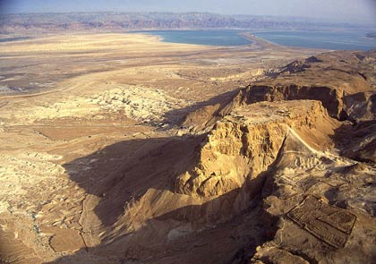
Israel offers backpackers both historical sites
and
beautiful landscapes like Masada, near the Dead Sea
Israelis may also have focused on hiking in the country due to the
long-standing (but now lessened) inability to travel outside it. Surrounded by
hostile neighbors, Israel’s citizens didn’t have the same luxury of a meandering
“road trip” as in North America or Europe. And only in the last 20 years have
Israelis earned enough to venture overseas. While today it’s almost de rigueur
for post-army youth to head out for adventures in South East Asia or South
America, the collective memory of when that wasn’t an option only further
emphasizes Israelis’ love affair with their own land.
Gorgeous and challenging trails
Fortunately, Israel offers an over-abundance of gorgeous and challenging
hikes, from the waterfalls of the Golan Heights to the breathtaking views
overlooking the Red Sea. Israel’s trails are clearly marked by colors painted on
rocks and tree trunks (the SPNI has a crew of volunteers who regularly check on
the markers), and there is a set of 20 glossy maps you can buy (about $25 each)
that will keep you moving in the right direction. The maps are available only in
Hebrew, but the SPNI is looking for donors to produce English-language versions.
Linking it all together is the 580-mile long Israel Trail, which starts in
the northern Galilee and winds its way south until it reaches the tip of Eilat.
Inspired by the Appalachian Trail in the US, the Israel Trail was officially
marked in 1995 and for the most part follows existing routes. It is indicated by
distinctive white-, blue- and orange-striped trail markers (white for the snowy
peaks of Mount Hermon, blue for the water and orange for the desert).
The Israel Trail is not a straight shot from north to south, hence its length
of nearly double the actual miles from one end of the country to the other.
Rather, it winds its way through the country’s most scenic geography, zipping
over to the Mediterranean coast and the central Tel Aviv area before snaking up
to the hills surrounding Jerusalem, then plunging south into the Negev and Arava
deserts.
The SPNI is working with the Jerusalem municipality to mark a 25-mile round
trip “spur” from the Israel Trail into Jerusalem, covering both urban and forest
areas of the capital city.
The Israel Trail specifically avoids regions still in contention, such as the
Golan Heights and the West Bank. It also must avoid army training grounds, which
take up about 60 percent of the Negev.
Hiking in Israel is a seasonal activity, best done in the fall and spring.
The Israel Trail has become a rite of passage, as a growing number of Israelis
choose to hike its entire length over two to three months. While much of the
time trekkers don’t have any choice but to pitch their own tents for the night,
designated "Trail Angels” along the route provide hospitality – often in
their homes – at low rates. Trail Angels can also be found on kibbutzim, and
some even have free WiFi connections.
Top Israeli hikes
The SPNI recently finished marking a new route dubbed “The Jesus Trail.” It
connects important sites from the life of Jesus, and runs for 40 miles from
Nazareth to Capernaum, all in the Galilee region. The idea was initiated by an
Israeli entrepreneur who runs a chain of hostels, including the Fauzi Azar Inn in
Nazareth.
Among the most popular treks in Israel, hikers can choose from a relatively
leisurely route (albeit with a few ups and downs) to death-defying challenges,
rappelling down cliffs or jumping past waterfalls.
Here are a few favorites:
The Burma Road is one of the easier routes, and also one steeped in history.
During the War of Independence, the Jordanians blocked the main route into
Jerusalem, attempting to starve the city into surrender. Under the cover of
night, soldiers from the nascent state of Israel clandestinely built a bypass road, which succeeded in breaking the blockade.
The trail starts just outside of Beit Shemesh. You can hike the western part
of the trail in the direction of Latrun. You’ll turn north before then, though,
to make a loop back to your starting point. This takes you through a pine forest
known as Park Rabin. There is also a bike rental shop, as the trail is popular
with cyclists.
The eastern flank of the trail is a bit tougher, and kicks off with a steep
ascent until reaching the village of Beit Meir. Along the way are some great
views of the highway far below. Both sections follow the Israel Trail for much
of the route.
Another pleasant hike goes through Nahal Amud (“nahal” means “dry canyon” in
Hebrew; the Arabic “wadi” is often substituted). This trek is in the Galilee
area – it runs from Mount Meron in the west toward the Sea of Galilee in the
east, passing close to the kabalistic town of Safed. In addition to following
the Israel Trail, Nahal Amud is particularly shady, even in the summer.
The highlight of the hike is the water – this nahal is not a dry creek – and
the pools are frequently filled with campers from the various youth movements.
If you can make it past the crowds, you’ll follow the river, then loop back past
ancient flourmills before reaching the spacious parking lot (and an ice cream
stand – a nice treat at the end of your day).
If adventure is your game, the lower part of Nahal Dragot (more popularly
known by its Arabic name, Darga) will keep your heart beating. Located in the
Dead Sea area, the Darga is incredibly challenging with 50-meter high walls, dry
waterfalls and pools of natural water in craters that you have to swim across.
Although there are metal stakes hammered into the rocks in some places, you
really can’t do this hike without bringing a rope. Or, in some places, skip the
rope and jump into the water instead. Warning: Don’t do this hike without a
buddy!
Another challenging hike with rungs and water is in the Golan Heights. In
Nahal Yehudiah, the water is so deep you have no choice but to swim to reach the
other side. The path starts by passing a deserted Syrian village that was built
on top of an earlier Jewish town from the Roman-Byzantine period. Further down
the valley is the 20-meter-high Yehudiah Falls.
There are two cliffs to climb down using ladders drilled into the side of the
rock – one is four meters (13 feet) long, the second nine meters (29.5 feet),
ending in the pool. Make sure your belongings are wrapped up in waterproof bags,
or do like some of the more creative hikers who pack small inflatable boats to
float their gear across.
Water is also the calling card of Wadi Kelt, by far one of the most popular
hiking spots in Israel, with some 60,000 visitors a year. The hike, which
parallels the Jerusalem-Dead Sea highway, cuts through a deep desert gorge. Even
in the heat of the summer, the high canyon walls and the water make this a
pleasant refuge.
At the end of the hike is the Greek Orthodox Monastery of St. George; the
monastic community here dates back to 420 CE. If you were to continue on, you’d
reach Jericho. Instead, Israelis either double back through the nahal or take a
quicker (but less scenic) road that runs along the top of the canyon. Better
yet, take two cars and park one at each end. That way you can spend more time in
the water.
If you prefer to look at water, Mount Zefachot is particularly spectacular.
This Eilat-area tiyul starts from the road that leads to the Egyptian border at
Taba. There is a steep ascent with some tricky ups and a few cliffs to keep it
interesting. But this hike is all about the payoff: From the top of the
mountain, you get a panoramic view of the entire Red Sea area. You can see four
countries from this vantage point: Israel, of course, but also Jordan, Egypt and
the tip of Saudi Arabia. The sea remains a shimmering blue year round, and
Eilat’s mild winters make this a perfect hike to break the cold of Israel’s more
northern locales.
There are many more hikes than this short summary can review – the scenic
Nahal Katlav in the Jerusalem area, the famous David’s Waterfall at Ein Gedi,
the Black and Red Canyons further south. So, if you’re angling to act Israeli on
your next trip, once you’ve hit up the Old City, the Tel Aviv beaches and
Israel’s unique museums, take to the mountains and valleys. Somewhere among
those 6,000 miles of trails, there’s bound to be a color-coded marker with your
name on it.