By Avigayil Kadesh
A new 42-kilometer (26-mile) hiking and biking trail around the southern Israeli city of Beersheva recently won a special prize for the Society for the Protection of Nature in Israel (SPNI) and its Israel Trails Committee, in the annual ECO-Award competition sponsored by the European Ramblers Association.
Officially known in English as the Round Be’er-Sheva Trail (RBST), the path encircles Israel’s seventh-largest city, which has a population of about 195,000 and is also known as the “capital of the Negev.”
Pieced together and enhanced from a nucleus of previously separate trails, the RBST leads hikers and bikers around the urban area of the city, passing near world and local heritage sites, archeological and historical sites and Christian, Muslim and Jewish religious sites.
The RBST was designed specifically as a “green belt” bordering the open and built parts of the city, taking into account the need to both participate in, and minimize, the impact of Beersheva’s natural expansion needs in the future.
This unusual urban-environmental model is what won the notice of the Ramblers Association.
Five-part route
The idea for the trail actually came from a group of teens who were exploring around Beersheva during a teachers’ strike in 2007, says SPNI-Beersheva’s Ronit Zeevi. They happened across ruins of Byzantine-era water cisterns on the outskirts of the city and came to the SPNI office to tell her about their discovery.
“They said, ‘We found water cisterns and we should do something with it,’ and we realized there are so many archeological and nature sites, why not make a trail around Beersheva so people who know nothing about the region can come and learn?” she recalls.
The SPNI organized meetings among all concerned parties, representing the city of Beersheva, the Israel Nature and National Parks Service, the Jewish National Fund, the Antiquities Authority and the Committee for Israel’s Hiking Trails. In 2008, the route was marked and the work began.
“We decided to divide the route into five parts marked in five different colors, because it’s almost marathon length and people can’t walk everything in one day,” Zeevi explains.
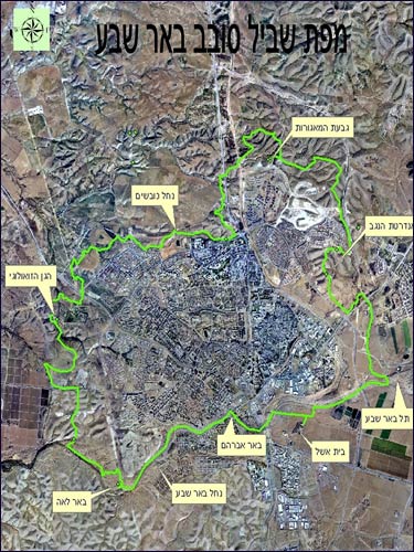
Map of the RBST Photo courtesy SPNI/Israel Trails Committee The path was mapped in such a way that eventually it will meet up with the Israel National Trail via a series of smaller branches still to come.
Finally, in March 2012, Mayor Ruvik Danilovich officially inaugurated the RBST, accepting municipal responsibility for the upkeep of the trail.
The local SPNI is planning many kinds of activities to introduce the RBST, including guided tours and perhaps a marathon, taking advantage of the length of the entire trail.
“A lot of schools ‘adopted’ the part of the trail where the water cisterns are, and the kids did research and cleaned up the place, and went with their parents on special days to explore,” she says.
Linking old and new
Beersheva has been known since biblical times. It is first mentioned in Genesis as the name of the desert region at the northern edge of the Negev where the patriarchs Abraham and Isaac made their home.
Its name may mean either “Well of Oath” or “Well of Seven,” referring either to the oath of cooperation taken there between Abraham and the regional king Abilmelech, or the seven wells later dug by Isaac at the same location.
The modern city was built adjacent to the archeological tel, or mound, where several layers of the remains of settlement date from the early Israelite era to the Roman period. Today’s Beersheva is a thriving metropolis anchored by Ben-Gurion University and the Soroka Medical Center.
The planners of the RBST took care to make use of existing topography and paths, rather than building special new bike and hiking routes, and to use elements and sites along the route to create centers of activity. The area’s natural resources, flora and fauna were carefully preserved.
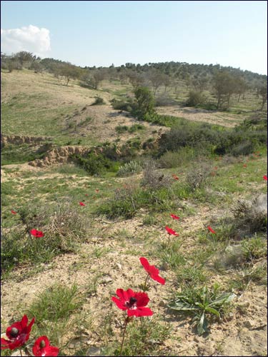
Wildflowers along the RBST route
Photo courtesy SPNI/Israel Trails Committee “The trail passes just 200 to 300 meters from some neighborhoods, and brings people past the Negev Brigade Monument; Neve Menachem, where a new stadium is being built; and an area with unique flowers where we hope to make a small nature reserve,” says Zeevi.
“In the west it passes next to the Zoological Garden, in the south through what will be a huge park on the Beersheva River and the Beit Eshel historical site from 1943, in the east not far from the Tel Beersheva Archeological Park, and in the north next to [the suburb of] Omer. It touches history, archeology, urban sites, nature, water, trains ... everything.”