By Avigayil Kadesh
Israel’s unique-in-the-world working system for predicting the behavior of forest fires is beginning to revolutionize how these potentially deadly incidents are handled – and save countless lives, trees and property at the same time.
The Matash Fire Forecasting System deployed in the summer of 2012 was born out of the tragedy of the Carmel Forest fire in December 2010 -- the worst fire in Israeli history, claiming 44 lives, destroying five million trees in the Carmel Forest and damaging residences.
One of the most difficult and dangerous aspects of fighting any forest fire – an average 1,000 of them occur each year in Israel – is predicting how the blaze will spread. Often, decisions about sending equipment and personnel, or whether to evacuate residents of surrounding communities, are sheer guesswork.
The research department of Israel’s Ministry of Public Security took a closer look at European and American theoretical scientific models for predicting the behavior of forest fires using Weather Research Forecasting (WRF). They then built a simulation of how such a system could have provided critical information to those battling the Carmel blaze.
Matash grew out of the success of that simulation, says Shai Amram, geographic systems information manager for the ministry’s research department. “This is the first operational WRF system in the world,” says Amram.
He and Research Director Besora Regev demonstrated Matash to international representatives at a homeland security conference in Tel Aviv in the fall of 2012. Delegates representing countries such as Spain, Bulgaria, Italy, Croatia, South Korea and Kenya expressed keen interest. Because the system was built in English, it could be useful anywhere in the world.
Unprecedented capabilities
Matash works by crunching data concerning weather, topography and infrastructure as soon as firefighters report their exact location.
Using live feedback as well as sources such as Google Maps and Google Earth, the system provides a complete picture based on temperature, relative humidity, precipitation and wind direction and speed; as well as topographical conditions, location of flammable materials and the moisture level of vegetation on the scene.
The results are unprecedented in the history of firefighting.
“After we hear from the firefighters in the field, in 15 minutes we get predictions for one hour ahead,” says Amram. “After 30 minutes, we get six hours ahead.”
Personnel at the Israeli Fire and Rescue control center in Rishon LeZion use the system’s forecasts as a tool for decision-makers having to make fast life-or-death judgments about deployment of firefighters and equipment, and evacuation of civilians.
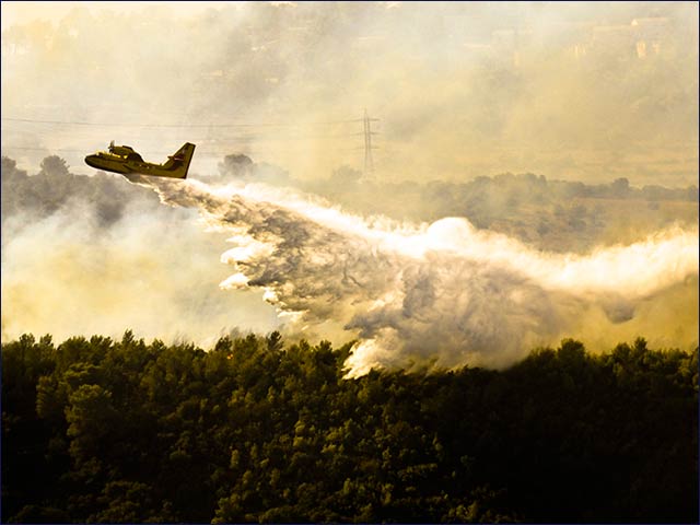 The prediction system will help decision-makers more
wisely deploy equipment and personnel to fight fires.
Photo courtesy of KKL-JNF
Regev says Matash is at the disposal of every firefighting, police and rescue agency in Israel, including Keren Kayemeth LeIsrael-Jewish National Fund and the Israel Nature and Parks Authority, which administer the country’s 400,560 acres of forest.
The system is one of several advanced technologies to come out of the Israeli government’s decision to create a National Fire Authority following the Carmel disaster. The law changes the structure of the fire service from a municipality-based, divided force, into a single, unified, national force under the auspices of the Public Security Ministry.
Tried and true
Matash quickly proved its capabilities in real time.
“Last summer, there were two big fires near Jerusalem, in Motza and Ma’aleh Hachamisha,” says Regev. “The system was very helpful for predicting a few hours ahead for the worst-case scenario that we do not want to get to.”
With the aid of Matash, the fires were controlled before dire scenarios could develop.
In addition to predicting how the blaze will behave over the next few hours, Matash presents decision-makers with a two-dimensional map; 3D imaging of fire temperature, fire line advancement and height of flames; maps of potential additional fires and high-risk areas; and weather forecasts for the next three days at a 1.3-kilometer resolution.
The system has an accuracy level of within 50 meters and updates itself every six hours.
When there are no fires, the Matash system can be used in simulation mode to help officials prevent and prepare for future fires.
Experts analyzing the simulation can suggest steps that should be taken by municipalities in fire-prone areas to protect against tragedies, and firefighting agencies can map best routes for evacuation and firefighter deployment to be ready in case a fire occurs.